
|
Carnac (Karnag):
|
Carnac (Karnag)
Quiberon (Kiberen)
Morbihan
Bretonio
Bretagne Britanny
Francio Frankreich France
Eŭropo Europa Europe
Index
 Domaĝe
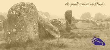
la vicojn tranĉas la strato de Carnac al Rutel post 300 m. Poste, post
la 500a metro la liniojn turniĝas iom norden kaj kontinuas nun al 87°
al orient-nordorienten. Post kelkaj pluaj cent metroj la aranĝo duafoje
estas tranĉata de stratego. Nombraj ŝtonoj viktimiĝis pro tiu
afero. Oriente de tio ili finiĝas, ŝajne malaperantaj en la herbaro
kaj arbustaro. Plue oriente tiam komencas la ŝtonvicoj de Kermario.
Domaĝe
la vicojn tranĉas la strato de Carnac al Rutel post 300 m. Poste, post
la 500a metro la liniojn turniĝas iom norden kaj kontinuas nun al 87°
al orient-nordorienten. Post kelkaj pluaj cent metroj la aranĝo duafoje
estas tranĉata de stratego. Nombraj ŝtonoj viktimiĝis pro tiu
afero. Oriente de tio ili finiĝas, ŝajne malaperantaj en la herbaro
kaj arbustaro. Plue oriente tiam komencas la ŝtonvicoj de Kermario. Ambaŭfine de la linioj videblas la restoj de ovecaj ŝtoncirkloj (kromleĥoj). La fama arkeoloĝisto Alexander Thom [Aleksânder Tôm] sukcesis disspecigi la kromleĥojn laŭ diversaj tipoj. Tiel li povis pruvi ke tiuj tipoj ne nur ekzistis en Bretonio sed ankaŭ sur la Brita insularo. Krome li pruvis ke ili estis formataj ovece (ĉi-tie: ebenigita nur unu flanko!) intence ĉe kio por ĉiu tipo validas certa, ne malkomplika rilato de diversaj longecoj.
La okcidenta kromleĥo estas de tipo 1. Ĝi longas 76,6 m kaj larĝas 60 m Ĝia longa akso montras al 351°, sekve la mallonga akso montras al 81° ĉe kio la ebena flanko troviĝas norde. De ĝi restas ĉirkaŭ 70 ŝtonoj, verŝajne la duobla kvanto ĝin formis oriĝine. La cirklo ne ĝuste kontinuigas la liniojn sed delokiĝas iom suden, tiel ke (imagaj) plilongigoj de la nordaj ses linioj preterpasus la kromlexhon. La orienta ŝtoncirklo estas tipo 2 kun longeco de 106,5 m kaj larĝeco de 91 m. Ĝia longa akso montras al 124° nordokcidenten, la ebena flanko troviĝas en la sudoriento. Domaĝe tiu ringo tre severe estas damaĝita. Kelkaj ŝtonoj formas la finon de la linioj, kelkaj ceteraj ŝtonoj troviĝas norde de ili kaj formas la akutan nordflankon de la ringo. Cetere la konturo devis esti rekonstruata.
La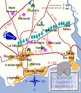 ŝtonaj vicoj de Le Ménec situas norde de la ĉarma urbeto Carnac,
ĝuste oriente de la vilaĝo Le Ménec en la departemento Morbihan
en suda Bretonio (Regiono en okcidenta Francio) . Ili laŭiras kun la tri
ceteraj ŝtonlinioj la ĉefstraton D 196 orienten ĝis Kerlescan.
Belan vidon sur la tutan aranĝon oni havas vidante nordokcidenten de la
tomba altaĵo (tumuluso) St. Michel [San Miŝel] ĉe la orienta
urbobordo de Carnac.
ŝtonaj vicoj de Le Ménec situas norde de la ĉarma urbeto Carnac,
ĝuste oriente de la vilaĝo Le Ménec en la departemento Morbihan
en suda Bretonio (Regiono en okcidenta Francio) . Ili laŭiras kun la tri
ceteraj ŝtonlinioj la ĉefstraton D 196 orienten ĝis Kerlescan.
Belan vidon sur la tutan aranĝon oni havas vidante nordokcidenten de la
tomba altaĵo (tumuluso) St. Michel [San Miŝel] ĉe la orienta
urbobordo de Carnac.
Die Steinreihen von Le Ménec wurden um 3000 v. Chr. errichtet und bestehen aus 1099 Menhiren aus grauem Granit in 12 fast parallelen Reihen. Die ganze Anlage ist etwa 100 m breit und 1167 m lang. Diese Steine sind der Größe nach sortiert, im Westen erreichen sie eine Höhe von fast vier Metern, im Osten sind sie kaum 60 cm hoch. Zunächst ziehen sich die Linien 500 m weit nach 93° Ostsüdost. Auffällig ist ein hoher Menhir auf der vierten Reihe von Norden bei etwa 200 m vom westlichen Ende der Alignements. Seine Bedeutung ist bislang ungeklärt, wie auch die Bedeutung der ganzen Anlage. Leider werden die Reihen nach 300 m von der Straße von Carnac nach Runel zerschnitten. Dann, nach 500 m machen sie einen Knick leicht nach Norden und verlaufen somit in Richtung 87° nach Ostnordost. Einige hundert Meter weiter wird die Anlage abermals von einer Straße zerschnitten. Zahlreiche Steine müssen diesem Vorhaben zum Opfer gefallen sein. Östlich davon laufen sie dann aus, scheinen sich im Gestrüpp und hohen Gras zu verlieren. Weiter nach Osten beginnen dann die Steinreihen von Kermario.
An beiden Enden der Alignements lassen sich die Überreste eines eiförmigen Steinkreises (Cromlech) erkennen. Dem berühmte britische Archäologe Alexander Thom war es gelungen, die Cromlechs in verschiedene Typen einzuteilen. Damit konnte er nachweisen, daß diese Typen sowohl in der Bretagne als auch auf den britischen Inseln existieren. Ferner wies er nach, daß sie absichtlich eiförmig (nicht zu verwechseln mit oval, sondern nur an einer Seite abgeflacht.) gestaltet wurden, wobei für jeden Typ ein bestimmtes, nicht unkompliziertes Längenverhältnis zur Geltung kam.
Der westliche ist vom Typ I; er ist 76,6 m lang und 60 m breit. Seine Längsachse weist nach 351° N , die Querachse folglich nach 81°, wobei die abgeflachte Seite im Norden liegt. Von ihm sind noch etwa 70 Steine vorhanden, gut die doppelte Anzahl dürfte ursprünglich bestanden haben. Der Kreis schließt nicht direkt an die Alignements an, sondern ist leicht nach Süden verschoben, so daß (imaginäre) Verlängerungen der nördlichen sechs Steinreihen an ihm vorbeiführten.
Der östliche Cromlech ist vom Typ II mit einer Länge von 106,5 und einer Breite von 91 m. Seine Längsache zeigt nach 124° Nordwest, die abgeflachte Seite liegt im Südosten. Leider ist dieser Kreis äußerst stark beschädigt. Einige Steine bilden an seiner Westseite den Abschluß der Alignements, an der spitzen Nordseite sind ebenfalls noch einige Steine zu sehen. Im Übrigen mußte der Grundriß des Kreises nachträglich rekonstruiert werden.
Die Steinreihen von Le Ménec liegen nördlich des reizenden Städtchens
Carnac, direkt östlich des Dorfes Le Ménec im Département
Morbihan in der Bretagne. Sie ziehen sich zusammen mit den drei anderen Alignements
an der Hauptstraße D 196 nach Osten in Richtung Kerlescan entlang. Einen
schönen Überblick über die Anlage bekommt man vom Tumulus St.
Michel am östlichen Stadtrand von Carnac, wenn
man nach Nordwesten schaut.
The stone formations of Le Ménec were erected around 3000 B.C. and consist of 1099 menhirs of grey granite in 12 nearly parallel rows. The whole arrangement is about 100 m (110 yd) wide and 1167 m (0.7 mls) long. The stones are sorted according to their height from west to east. In the west are the tallest stones of up to four meters (13 ft) while those of the eastern end hardly reach 60 cm (2 ft) in height. From the beginning the rows extend for 500 m (0.3 mls) to 93° east-southeast. One stone in the fourth row from the north, about 200 m from the west is especially noted for its height. It must have had a special function which until now is as uncertain as the meaning of the whole arrangement.
Unfortunately the rows get split after 300 meters by the road between Carnac and Runel. Then after 500 m they turn slightly to the north and continue on to 87° to east-northeast. Some hundred meters furthe on the formations get split another time by a main road. Numerous stones must have become victims of that. To the east they seem to disappear in the hedges and high grass, while further to the east the formations of Kermario commence. At both ends of the formation we can find the remains of egg-shaped stone-circles (cromlechs). The famous archaeologist, Alexander Thom, succeeded in dividing the stone-circles into different types, so he could prove that these types exist in Brittany as well as in the British Isles. Furthermore he proved that they were egg-shaped intentionally (not to be confused with oval-shaped, since they are flattened on one side only). With each type a certain, fairly complex relationship between several lengths was valid.
The western cromlech is of type I; it is 76.6 m (84 yd) long and 60 m (66 yd)
wide. Its long axis is oriented to 351° north, the short one oriented to
81°, with the flattened side lying to the north. From this circle some 70
stones still
remain, though originally double that number may have been there. The circle
does not completely close up but is offset somehow to the south, so that imaginary
extensions of the six northern alignments would pass by the cromlech.
The eastern stone circle one is of type II, with a length of 106.5 m (116 yd) and a width of 91 m (99.5 yd). Its long axis is oriented to 124° north-west, the flattened side lies in the south-east. Unfortunately this circle is severely damaged. Just a few stones form the end of the alignment, with a few other stones to the north forming the sharp northern side of the circle. Apart from that the circumference of the circle however needs to be reconstucted at a later date. The stone formations of Le Ménec lie north of the charming town of Carnac, exactly to the east of the village of Le Ménec in the province of Morbihan in Brittany. Together with the three other formations they extend along the main-road D 196 to the east heading for Kerlescan. A beautiful view one can be had from the barrow grave (tumulus) St. Michel at the eastern end of the town looking towards the north-west.
There are several legends about these mysterious rows of stone. One of them talks about St. Cornelius. This Christian was persecuted by Roman soldiers for his faith. While fleeing he reached the Gulf of Morbihan, where he realised that this was the end. In front of him was the sea and behind him the Romans were arriving. In his need he implored to God to help him. So God turned the soldiers to stone. At Christmas however the curse is lifted for some hours so that the stone soldiers can quench their thirst at the river nearby, before they have to stand immobile for another year. But nobody has ever been able to see that.
lasta ĝisdatigo letzte Überarbeitung last update: 17-2w-02